


WI4EURECA: Delivering Climate Intelligence, Wildfire Risk Mapping and Environmental Monitoring Across Europe
The WI4EURECA consortium was awarded Phase 2 of the PCP WISE project after successfully completing Phase 1. Through this European collaboration, Arbonaut continues working alongside leading organizations in Earth Observation (EO), geospatial analytics, hydrological modelling, and environmental monitoring such as Planetek Italia, Latitudo 40, Agricolus S.r.l., Tracasa Global, Kompetenzzentrum Wasser Berlin (KWB), and D-Orbit to to develop advanced decision-support systems for climate adaptation, disaster risk reduction, and sustainable water management across Europe.
As climate change increases the frequency and severity of droughts, floods, wildfires, heat stress, and other environmental challenges, authorities require reliable environmental intelligence to assess risks, allocate resources, and improve preparedness. WI4EURECA addresses these challenges by combining satellite Earth Observation, LiDAR, remote sensing, artificial intelligence, hydrological modelling, and geospatial analytics to transform environmental data into actionable information for public authorities and decision-makers.
Challenge
Climate-related hazards are creating growing challenges for both urban and rural environments across Europe. Droughts threaten water availability, floods damage infrastructure and communities, and increasing wildfire activity places people, ecosystems, and assets at risk. At the same time, changing environmental conditions affect soil stability, vegetation health, forest resilience, and long-term land management.
For public authorities and infrastructure operators, understanding these risks requires the integration of multiple data sources, including Earth Observation, LiDAR, hydrological data, and environmental models. Traditional monitoring approaches often rely on fragmented datasets, isolated analyses, and manual interpretation, making it difficult to obtain a comprehensive understanding of evolving climate risks and environmental conditions.
As extreme events become more frequent, organizations increasingly need scalable environmental monitoring, wildfire risk mapping, and decision-support systems that transform large volumes of geospatial data into actionable intelligence. These capabilities are essential for supporting climate adaptation, disaster risk reduction, water resource management, and evidence-based planning across both urban and rural landscapes.
The PCP WISE programme required reliable environmental intelligence to:
- Monitor climate and environmental conditions across large geographic areas.
- Improve drought monitoring, flood risk assessment, and wildfire risk mapping.
- Support climate adaptation and disaster risk reduction strategies.
- Enable evidence-based water resource management and environmental planning.
- Strengthen emergency preparedness and response capabilities.
- Improve long-term environmental and landscape resilience.
Solution
The WI4EURECA consortium is developing a modular cloud-based decision-support system that integrates Earth Observation data, satellite-based monitoring, LiDAR, artificial intelligence, hydrological modelling, and geospatial analytics into a unified platform.
Within the consortium, Arbonaut contributes advanced forest intelligence and wildfire risk assessment capabilities that support climate adaptation planning, forest monitoring, and emergency preparedness.
During Phase 1, Arbonaut delivered:
- Wildfire fuel mapping products describing both surface and canopy fuel characteristics.
- Wildfire susceptibility and wildfire risk assessments across diverse landscapes.
- Wildland-urban interface (WUI) analyses around buildings and transportation infrastructure.
- High-resolution terrain models to support hydrological and flood modelling.
- Vegetation structure and forest canopy datasets for environmental monitoring.
- Tree species classification products supporting wildfire prevention and sustainable forest management.
The project combines these datasets with additional climate, water, and environmental indicators to create a comprehensive environmental intelligence framework for monitoring, forecasting, and decision support.
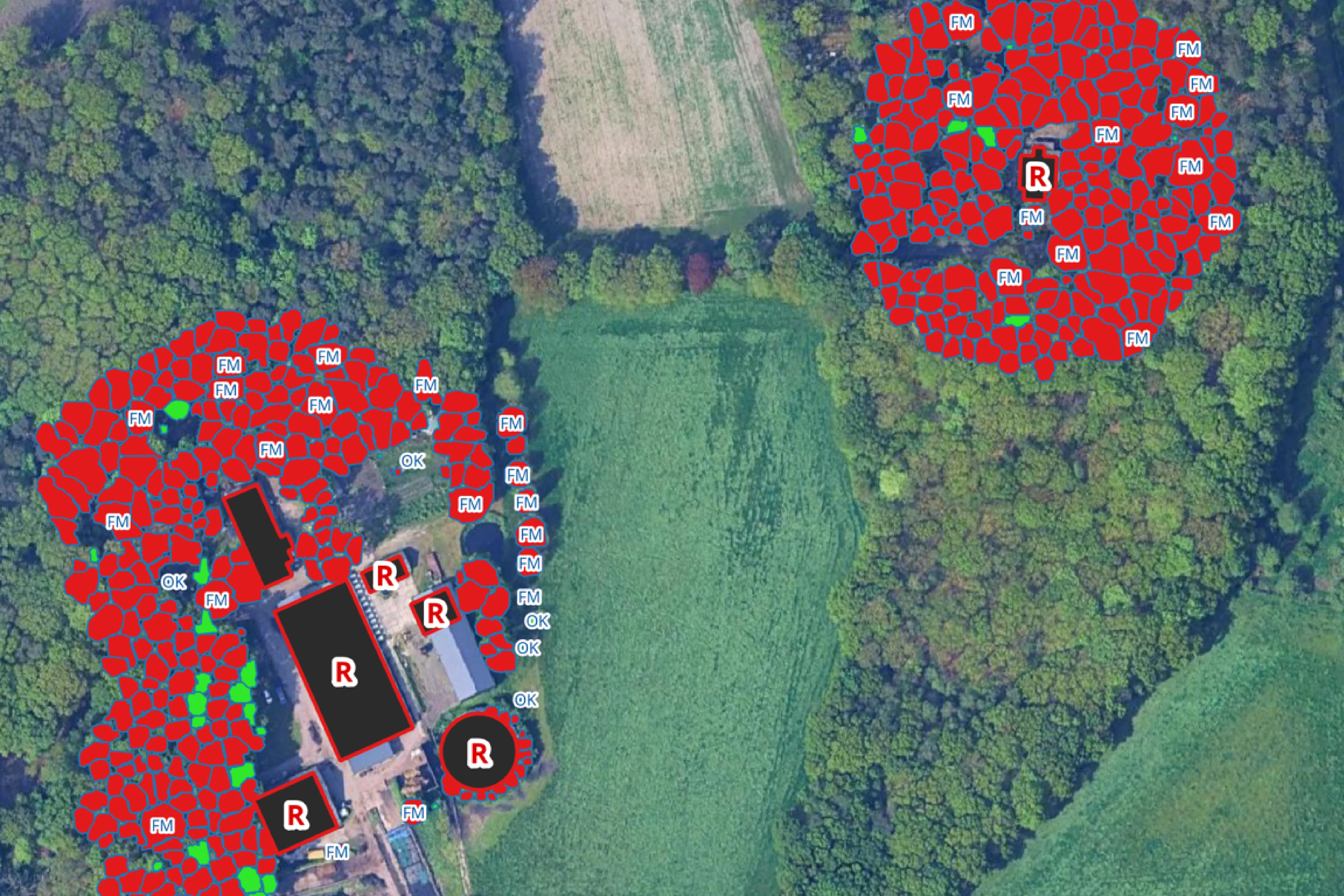
Detailed wildland-urban interface assessments identify vegetation surrounding buildings and roads and evaluate where fuel management measures can reduce wildfire risk, improve community protection, and strengthen climate resilience.
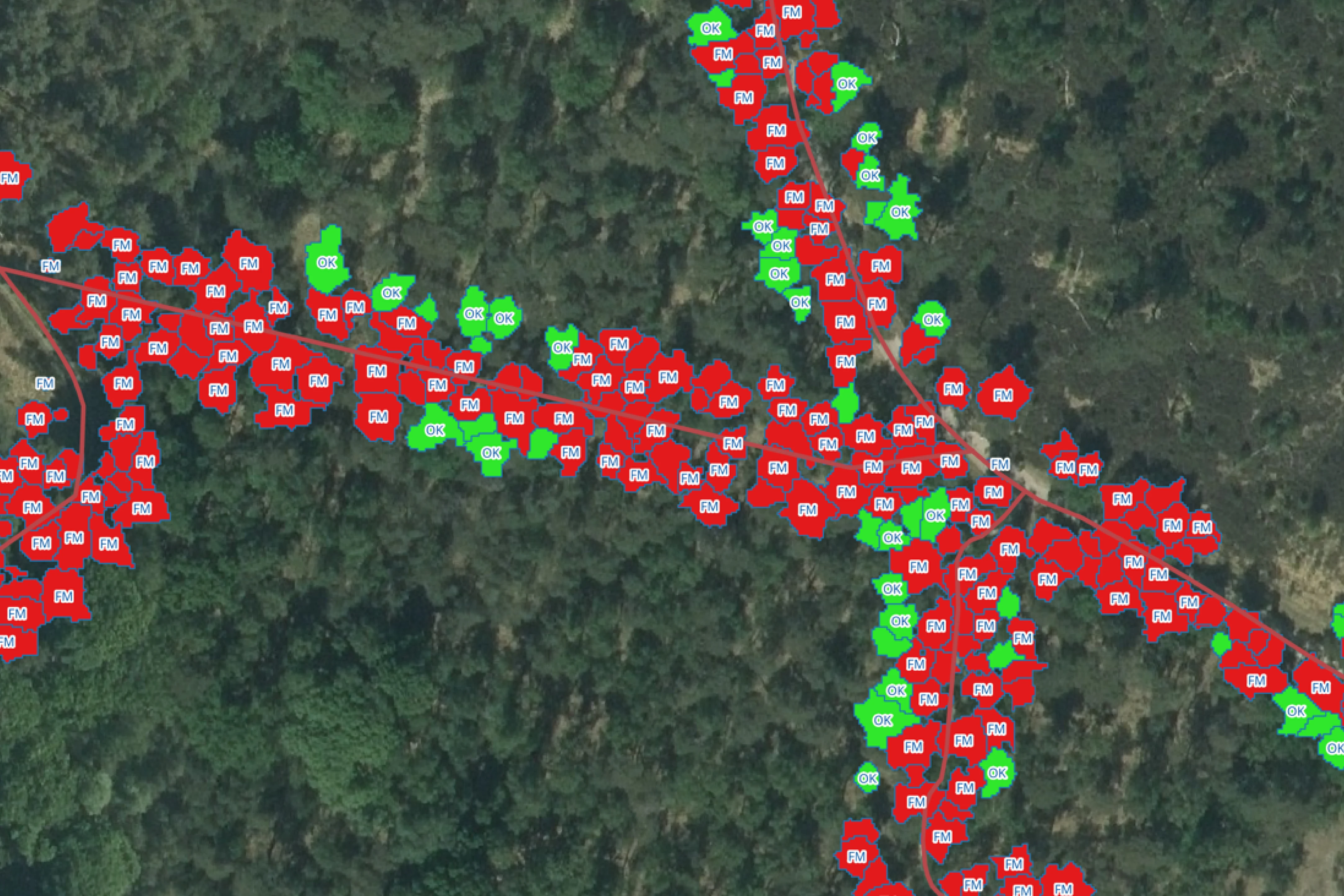
Wildfire fuel maps describe the spatial distribution of surface and canopy fuels, helping authorities better understand fuel continuity, wildfire behaviour, and areas requiring targeted fuel management interventions.
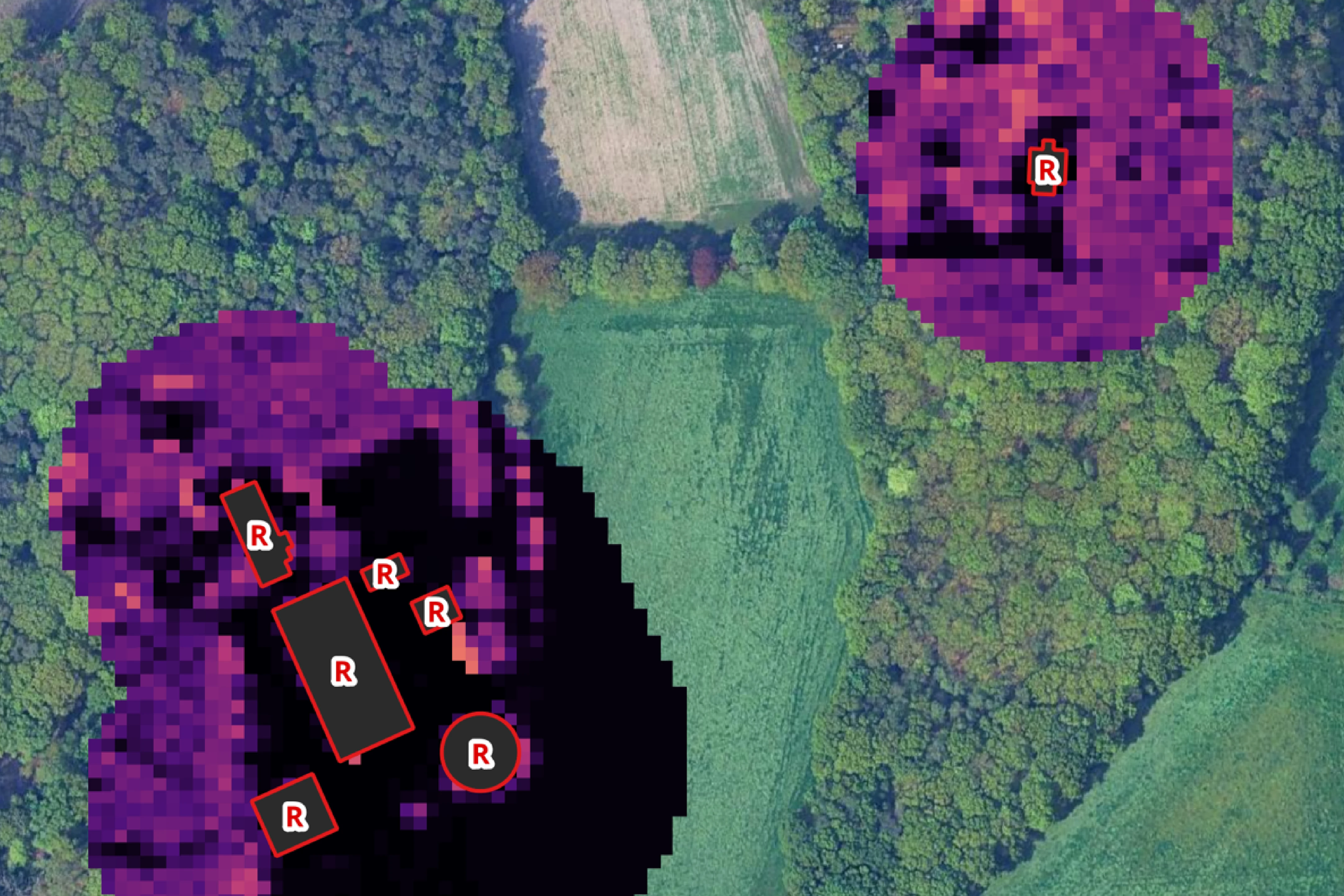
Advanced wildfire susceptibility models combine vegetation health, species composition, forest structure, and terrain characteristics to identify areas with varying wildfire risk and support wildfire prevention planning.
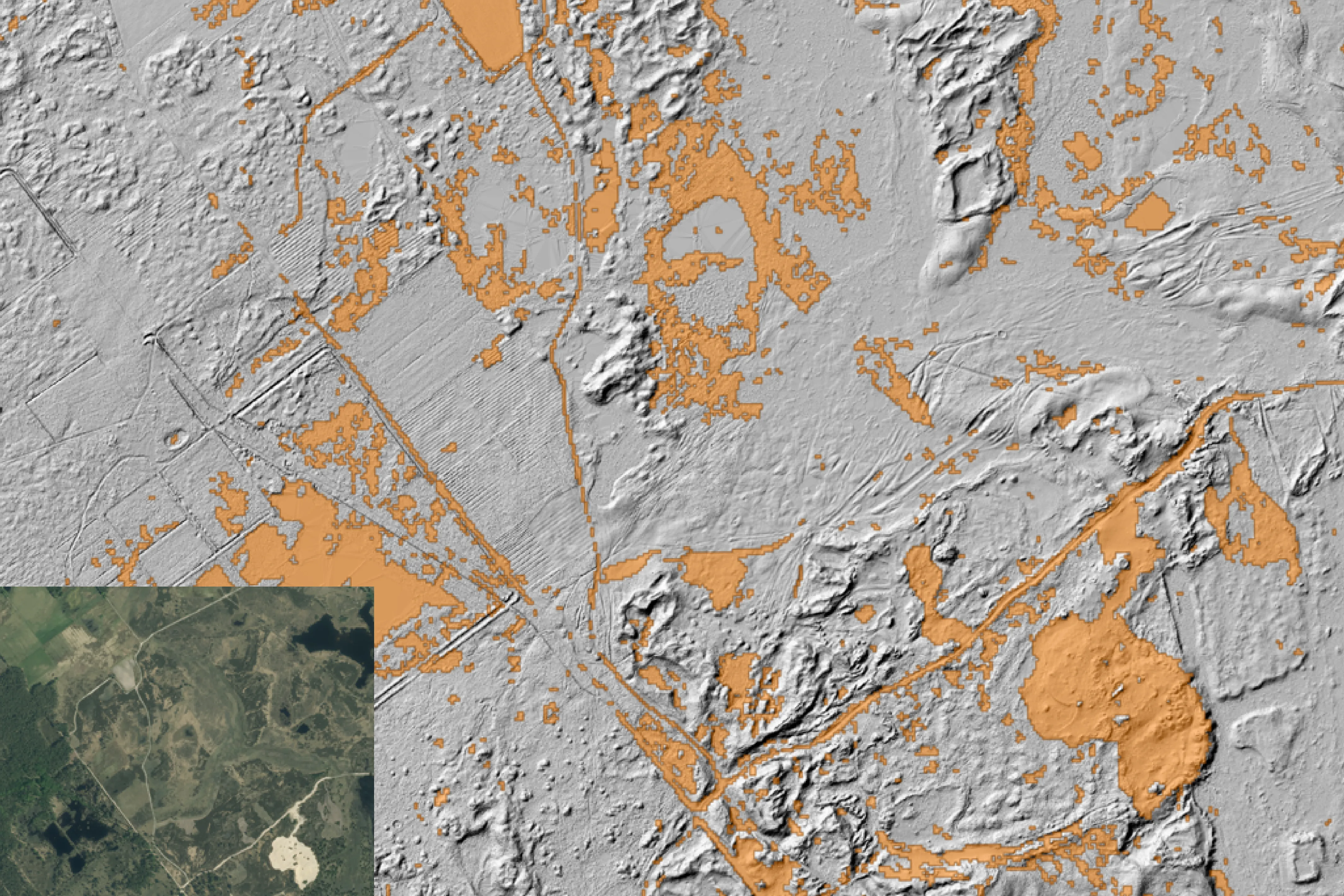
High-resolution terrain, vegetation structure, and tree species datasets provide critical information for environmental monitoring, forest resilience assessments, flood risk modelling, and climate adaptation planning.
Value
Authorities and stakeholders benefit from a comprehensive and spatially explicit understanding of environmental conditions and emerging climate risks, enabling:
- Improved climate risk assessment and scenario analysis.
- Enhanced wildfire preparedness, prevention, and fuel management planning.
- Better-informed water resource management and environmental decision-making.
- More efficient environmental and forest monitoring across large areas.
- Stronger support for emergency response and disaster risk reduction.
- Improved climate adaptation planning for urban and rural environments.
Beyond the immediate project outcomes, WI4EURECA demonstrates how Earth Observation, LiDAR-based forest inventory, AI-powered environmental monitoring, and geospatial analytics can be integrated into a scalable environmental intelligence platform. The project highlights how advanced decision-support systems can help authorities anticipate climate-related risks, improve environmental resilience, strengthen wildfire preparedness, and support sustainable management of natural resources across Europe.
About WI4EURECA
WI4EURECA (Water Intelligence for European Urban and Rural Environmental & Climate Assessment) is a multidisciplinary European consortium bringing together expertise in Earth Observation, hydrological modelling, civil engineering, agriculture, crisis management, and spatial data science. Through the PCP WISE programme, the consortium is developing a cloud-based climate intelligence and environmental decision-support system that helps public authorities manage droughts, floods, wildfires, and other climate-related risks through advanced monitoring, forecasting, and risk assessment capabilities.


 Cookie Policy