New GIS tool for assessing suitability of forestry clearance in Bhutan
Last year, Arbonaut has extended its global reach to Bhutan, a new country for us on the map, with the start of the development of a Spatially-enabled knowledge base and Decision Support System (SDSS) for the Department of Forest and Park Services.
New GIS tool for assessing suitability of forestry clearance in Bhutan
One year ago, Arbonaut has extended its global reach to Bhutan, a new country for us on the map. In January 2020 — before the global situation has changed due to COVID-19 — our experts Raisa Sell and Aapo Kuusela traveled to Bhutan to kick off the development of a Spatially-enabled knowledge base and Decision Support System (SDSS) for the Department of Forest and Park Services (DoFPS) of Bhutan financed by Forest Carbon Partnership Facility of the World Bank. In collaboration with Arbonaut’s local partner Green e-Solutions, the development process of the new GIS tool had commenced.
Did you know?
Bhutan is the only carbon-negative country in the world. 72.3 % of Bhutan is covered by forests. This large amount of tree cover has seen Bhutan becoming a natural carbon sink meaning that the country absorbs more carbon dioxide than it emits. Bhutan is also famous for its Gross National Happiness index based on four pillars including sustainable development and environmental protection, which contributes to the country’s carbon neutrality.
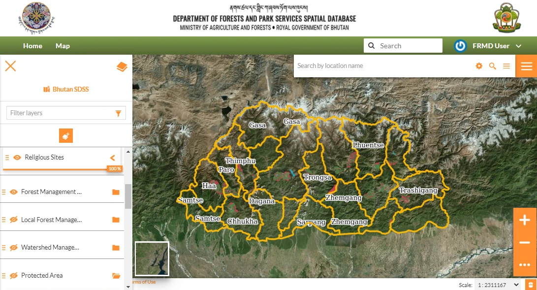
A new GIS tool for assessing suitability of forestry clearance
The Bhutan SDSS is a Geographic Information System (GIS) -based tool to facilitate informed, unbiased, and expeditious decisions on forest clearance. The tool comprises a spatial database and a decision support tool kit built from open-source products. The SDSS can provide rapid analysis of the proposed forestry clearance area within just a few minutes and deliver a report on the analysis based on existing criteria and rules. For example, the tool checks if the proposed forestry clearance area is close to a road, river, or water source, or inside a protected area, wetland, high canopy cover area or community forest.
The Bhutan SDSS is a Geographic Information System (GIS) -based tool to facilitate informed, unbiased, and expeditious decisions on forest clearance. The tool comprises a spatial database and a decision support tool kit built from open-source products. The SDSS can provide rapid analysis of the proposed forestry clearance area within just a few minutes and deliver a report on the analysis based on existing criteria and rules. For example, the tool checks if the proposed forestry clearance area is close to a road, river, or water source, or inside a protected area, wetland, high canopy cover area or community forest.
In the product development, our team had decided to adopt a platform for management and publication of geospatial data called GeoNode. Previously, GeoNode was used in our project in Pakistan. The reasoning behind choosing it for the project in Bhutan was simple: we needed software, which could be used to distribute and share geospatial, non-geospatial, and already existing data to create new maps in a web-based interface. As our customer did not require a mobile application where Arbonaut's software ArboFIS or ProMS would be more suitable for the development process, our team worked with GeoNode ticking all the boxes regarding DoFPS’s needs for the web-based tool.
Next steps: deploying the tool at a nationwide scale
With the successfully developed SDSS tool and incorporated centralized database with forestry sector and other data, without a doubt, we have achieved excellent results in the project. As an integral part of our technology transfer approach, around 15 forestry officers received training on how to use the system in their operations. Currently, these forestry officers are organizing additional training sessions for local-level users and deploying the system nationwide. And since the system was deployed at the Bhutan government servers, local IT officers were trained to maintain the system for years to come! We want to thank DoFPS for providing us an opportunity to collaborate with the department and contribute to the sustainable forest management in Bhutan!